


|
|
books
| book details |
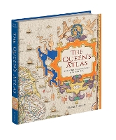
The Queen's Atlas: Saxton's Elizabethan Masterpiece
By (author) David Fletcher
|
| on special |
normal price: R 1 244.95
Price: R 1 120.95
|
| book description |
Nowadays, we take for granted the ready availability of maps of all kinds. In mid-Tudor England, they were rare. All this was to change in 1579 when Christopher Saxton, a farmer from the West Riding of Yorkshire, became the first cartographer to make a published atlas of all the counties of England and Wales. This book traces the story of Saxton’s life and legacy by reconstructing his extraordinary mapmaking project alongside the crucial nature of the support and encouragement he received from Queen Elizabeth I and her court. Saxton’s atlas became the template for most detailed maps of the country for almost two centuries: it is hard to exaggerate its importance. For many, his atlas provided the first detailed image of England and Wales they had ever seen, showing the Elizabethan kingdom as a whole and in its constituent parts. This lavishly illustrated book reproduces all Saxton’s county maps together with many other illustrations revealing the forebears and successors to this groundbreaking work. Today, Saxton’s maps give us an invaluable cartographic snapshot of late Tudor England.
| product details |

Normally shipped |
Publisher | Bodleian Library
Published date | 6 Nov 2025
Language |
Format | Hardback
Pages | 232
Dimensions | 250 x 210 x 0mm (L x W x H)
Weight | 0g
ISBN | 978-1-8512-4620-5
Readership Age |
BISAC | history / europe / great britain
| other options |

Normally shipped |
Readership Age |
Normal Price | R 1 436.95
Price | R 1 292.95
| on special |
|
|
To view the items in your trolley please sign in.
| sign in |
|
|
|
| specials |
|
|
|
|
Matt Dinniman
Paperback / softback
480 pages
was: R 522.95
now: R 459.95
|
|
An epic love story with the pulse of a thriller that asks: what would you risk for a second chance at first love?
|
|
|
|